I have been meaning to start this thread for awhile but due to the amount of effort involved to do justice, kept postponing it. Decided to do this in multiple posts as I find interest and time. This one will focus mainly on the basics, like a primer about the space - mainly on the technology involved with a brief intro to the geospatial policy and listed companies in this space.
Let’s start with what we mean by geospatial data since it encompasses a wide range of information.
Lat/long - Lets start with something we all already relate to - lat/long - or latitude and longitude which are coordinates used to specify locations on the earth’s surface. Latitude lines run horizontal and are also called parallels while longitude lines run vertical and are also called meridians.
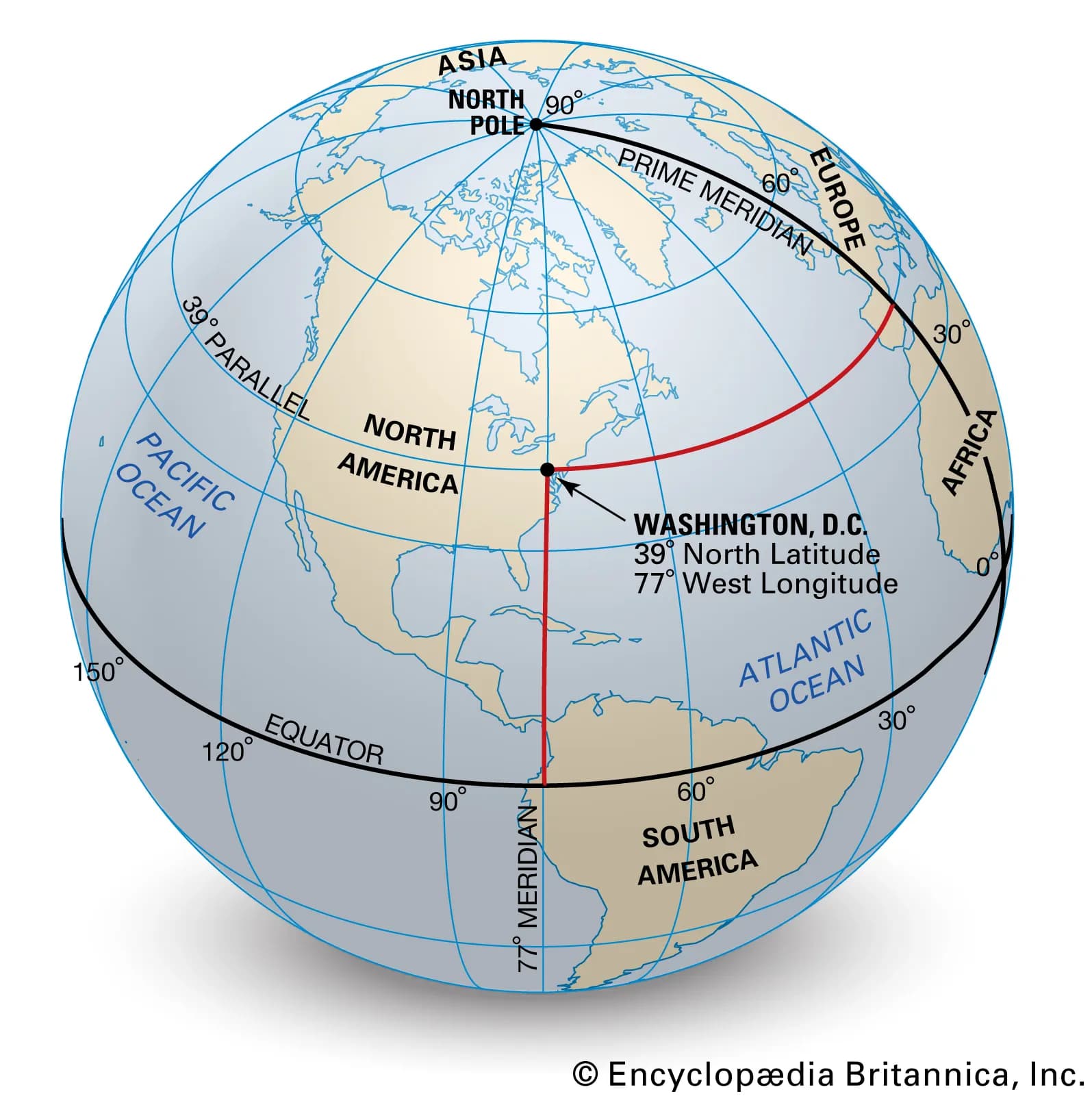
Both are expressed in degrees (and minutes and seconds or decimal degrees for additional precision). Any point on the surface of the earth can thus be expressed as a combination of latitude and longitude. In the image, the lat/long of Washington D.C. is shown (39° N and 77° W).
This has been sufficient enough for most applications we have been using so far, from charting (cartography) for denoting geographic features, cities and landmarks etc., to surveying (cadastral maps) to navigation maps used in applications like Google maps.
This however has some limitations - a lat/long while it denotes a point on the earth’s surface, it doesn’t deal with elevation information (altitude of earth’s surface, or which floor in a building at that location is etc.), doesn’t deal with human readable addresses and has been complex to communicate with precision (or for intuitive understanding). It also doesn’t tell us what the place looks like, what’s the weather like (additional attributes) and precise features of buildings or the insides of buildings etc. or keep track of things changing, which people might be interested in.
Addresses - House numbers, Road/Street names, areas, cities pin codes etc. This is something we have been using from the time postal system has been around and is the oldest known form of geospatial data (given a lat/long in a city, it is possible to get accurate associated address in most places)
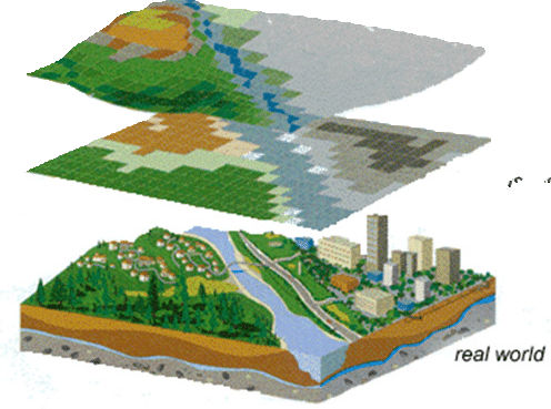
Vector data (Points, Lines, Polygons) - Points data is the simplest of vector data and represents a lat/long that corresponds to a point on earth. These could be used to specify addresses, landmarks, cities etc. Lines represent straight lines or curved lines that might represent a street or a river or a navigation route. Polygons represent closed regions on earth’s surface (could be a boundary of a town or a area, say like Koramangala). These are typically stores in a geospatial database as GeoJSON objects.
In a geospatial database, say for a e-commerce company that stores addresses of customers and also knows location of its warehouses - the points are stored as geometry objects (GeoJSON format) and these databases allow you to get distance between two points, points within region or check if point is within region etc. (Useful for delivery companies to see what’s serviceable or find nearest warehouse etc.). This calculation is currently done by these companies without need for any mapping data (all companies from BigBasket, Swiggy, Zepto etc. do it) but for real-time information on traffic and figuring out actual navigation (points within region doesn’t use navigation for figuring out distance) and actual distance etc. geospatial data from a third-party company like mapmyindia is essential.
Raster data (Satellite images) - This represents the earth surface data as a grid of pixels or cells. Each cell might represent an attribute on the surface - like temperature (to show a heatmap of India for eg.) or terrain type (like forest, river, city, building etc.). The resolution (spatial resolution) of these cells can vary. Technically there needn’t be any restriction on what this cell size can be in representation but regulations and also feasibility (of say putting sensors) could determine what this cell size in the grid will be.
This is a good eg. of how the real world gets translated into a raster image that shows the terrain as a satellite map in Google maps will represent
Multi-spectral data - Satellite images needn’t only be in RGB and can actually capture infra-red and ultra-violet as well. This is especially useful to monitor soil moisture, vegetation health, land cover and water quality (Carbon capture verification for eg. to issue certificates also uses this). Multi-spectral data can also be captured at higher resolutions with drones using remote-sensing. This data is typically used in Agriculture, Forestry, Environmental monitoring, Water resources, Urban planning and Disaster management
Multi-temporal data - This is monitoring the same area, using same grid and cell resolution across time - say to monitor an afforestation initiative or for carbon credits. Can also be used to compare weather across months or a river body over the seasons etc. Temporal resolution measures how frequently the data is collected. Higher the resolution, higher the cost incurred of course and so will depend on the type of application. A forest may need monitoring at weekly resolution but soil moisture in a farm at an hourly resolution and a forest-fire in minutes and so on
Geo-referenced Imagery - This could vary from simple geotagged images that show a restaurant or building photos, to more complicated street-view data captured using 360 degree cameras or building images in 3D captured using drones.
Sensor data - There could be data from IoT sensors across an area which are measured using physical sensor present in the location that stream the information periodically
LiDAR (Point-cloud data) - LiDAR stands for light-detection and ranging and involves sending a laser pulse and measuring time taken for it to bounce back from the surface to generate an accurate distance information for various points generating a point-cloud. It is typically used to generate elevation maps, structure of terrain and objects. In topography, it is used for high-accuracy elevation mapping (flood modelling, landform classification), judging canopy height in a forest and for mapping archaeological sites, historical monuments
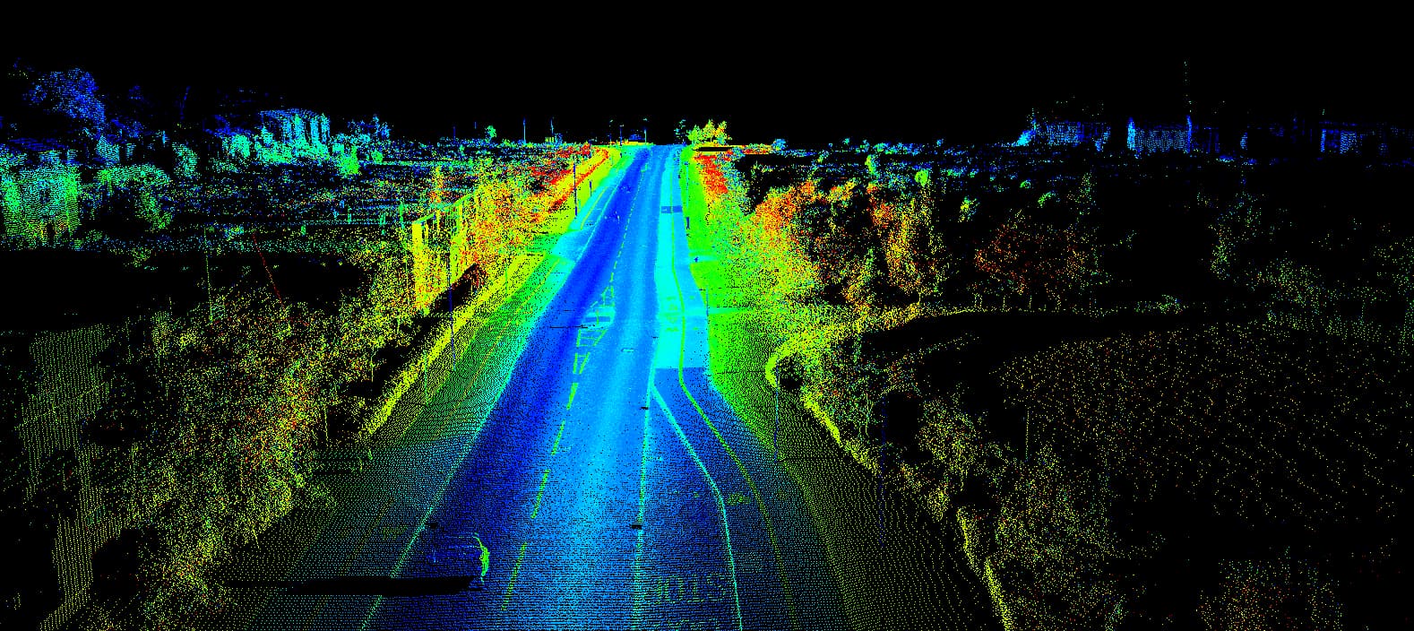
These days even iPhones come with a LiDAR sensor which is used for scanning 3D objects. Apple Vision Pro as well uses a LiDAR scanner to scan the environment and generate a point cloud so it can accurately place screens (what it calls spatial computing)
Point cloud data generated by LiDAR has millions and billions of points in 3D space with additional attributes for intensity and other attributes. Typically stored in LAS/LAZ format (LiDAR aerial survey. LAZ is compressed form of LAS)
Radar - Radar uses microwave to bounce off earth’s surface and is used in weather tracking. Like LiDAR, Radar is a active sensing technology (unlike multi-spectral or thermal data which is passive)
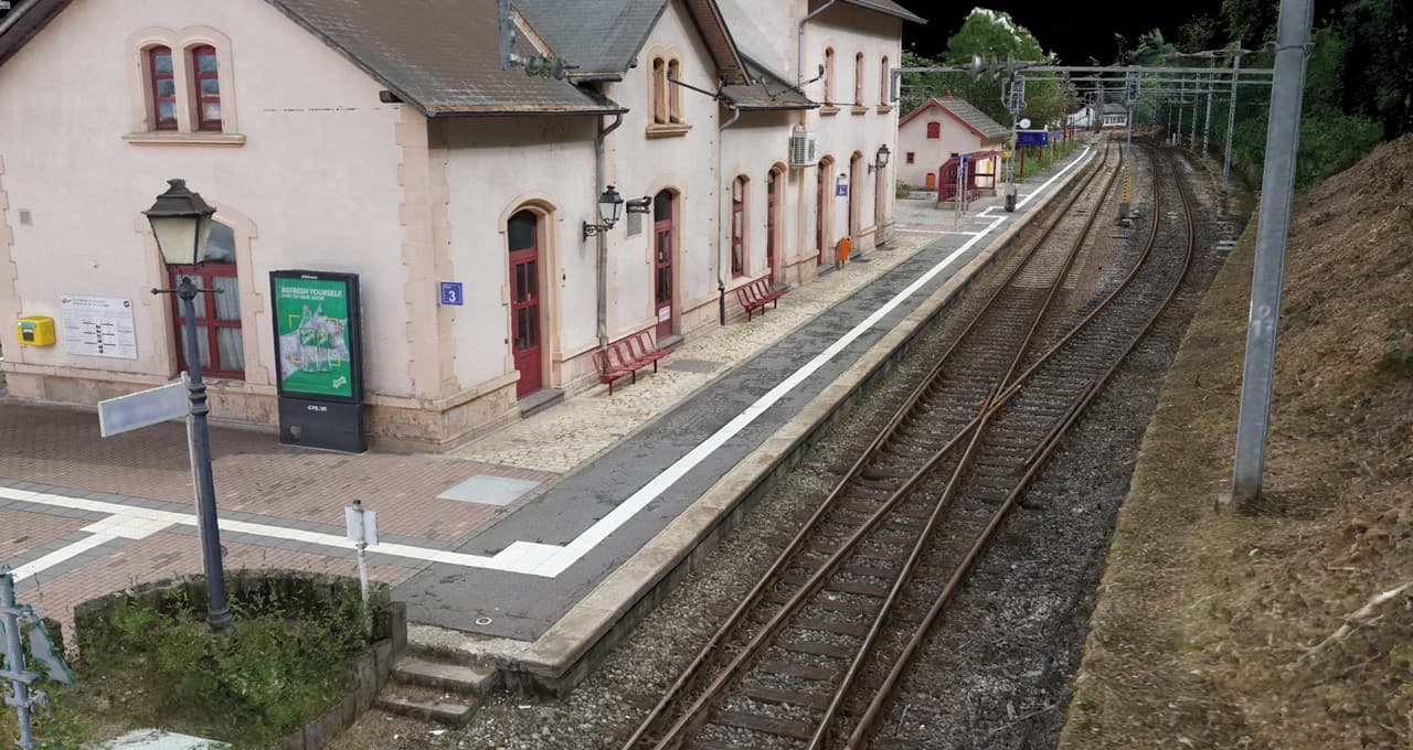
Photogrammetry - This is sort of similar to LiDAR but instead of using laser beams to measure deflections, here a 3D model is generated by simply taking high-quality 2D images from multiple viewpoints and reconstructing the 3D shape. This is typically done from drones or some other aerial photography. Application here too are similar to LiDAR.
Eg. of photogrammetrically generated 3D model
It should be clear by now that when we say “geospatial data”, it could mean a plethora of different types of data, captured by a variety of ways from manned land vehicles to drones or planes, to satellites, to drones with LiDAR or photogrammetry capability and used for a variety of purposes from urban planning, forestry, water management, navigation, logistics, ecological conservation, agriculture, mining, marine etc.
Highlights from Geospatial policies
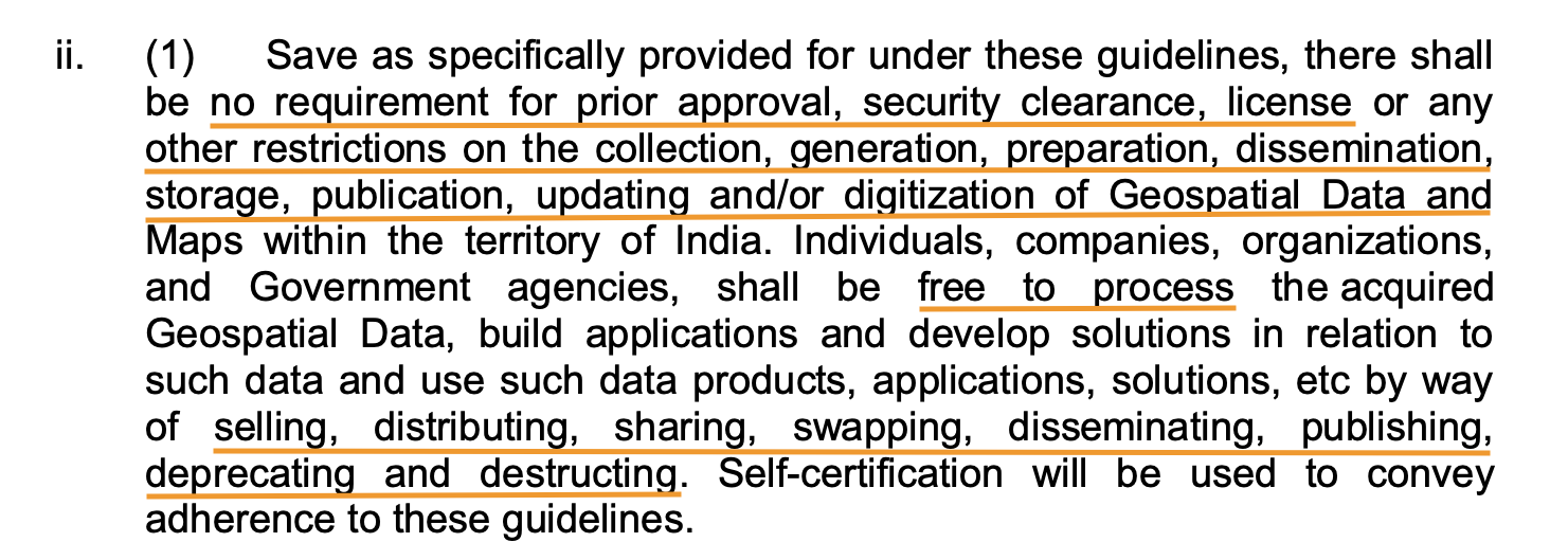
India has liberalised its geospatial policy in two recently announced notifications - Feb ‘21 and Dec ‘22. What I mean by liberalisation is this taken from the first doc. Earlier this was not possible.
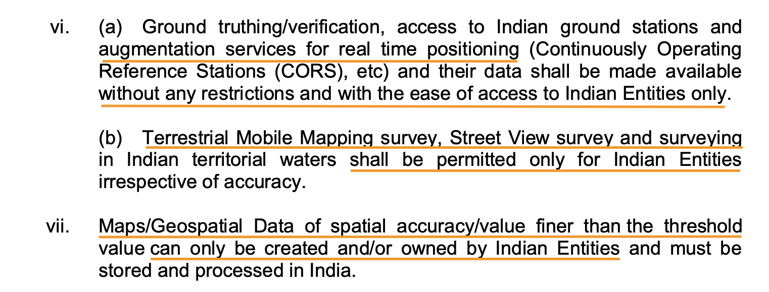
And there’s a natural moat in this for Indian companies. This is why Google licenses street view data from Genesys though they are perfectly capable of doing it on their own as they have done in other countries
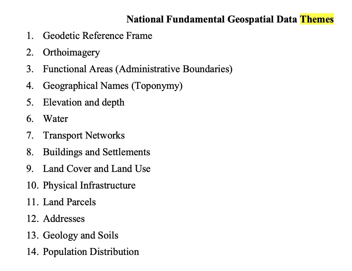
Areas where the govt. wants to focus on
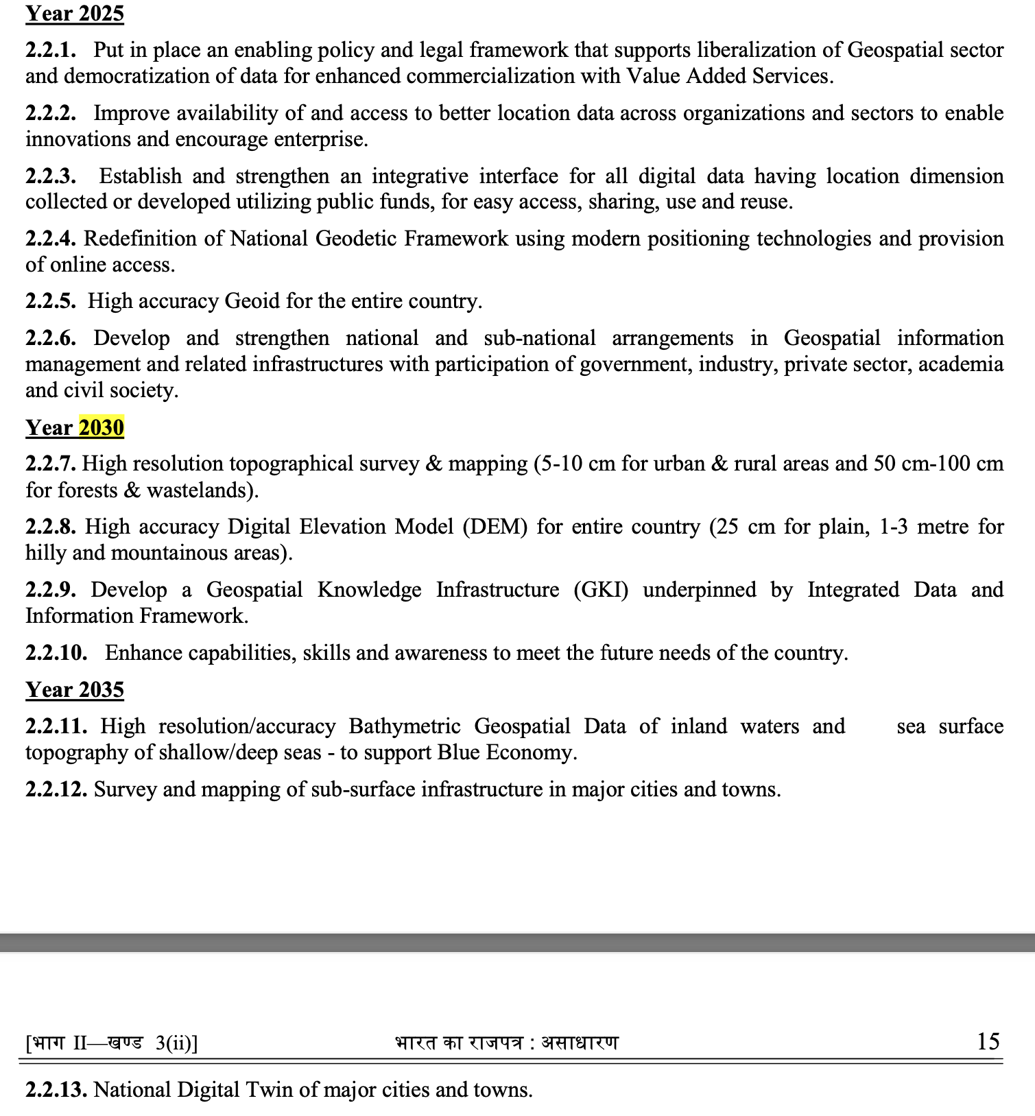
Govt’s vision of where we need to be in the next 10 years. We are just in year 1 of the geospatial evolution of the country
Brief overview of listed companies
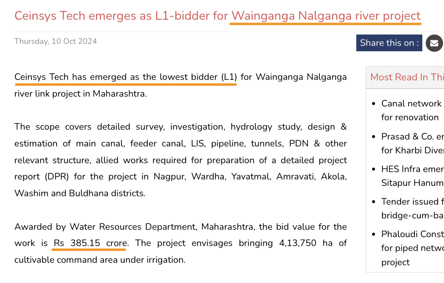
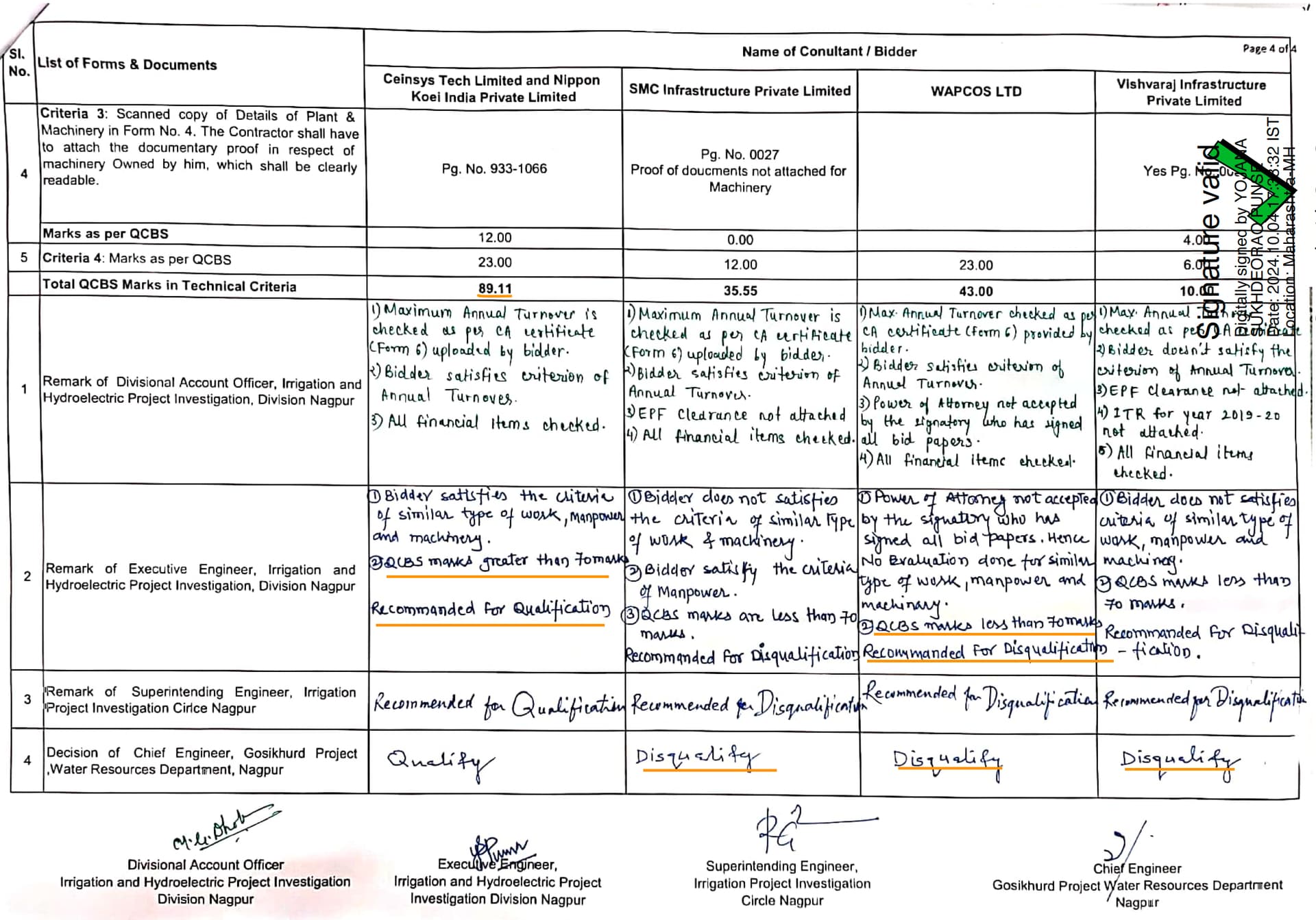
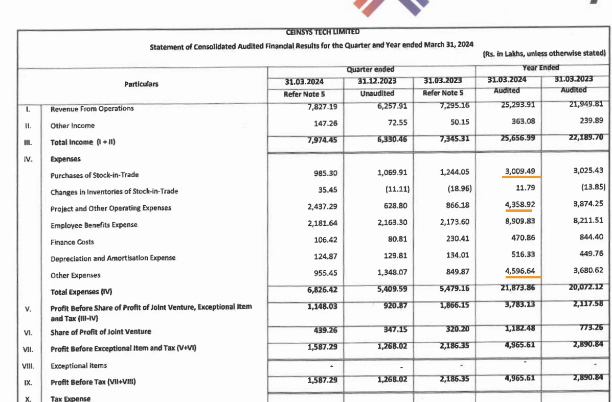
Mapmyindia is a pioneer in this space and has presence in automotive and e-commerce segments and focuses mainly in B2B and B2B2C segment. They appear to remain focused in this space with their product Mappls. Genesys is the company which worked with HERE maps and was mainly a service provider until the geospatial policy but has reinvented itself with the digital twin initiatives and has quickly built a platform for the same. Ceinsys is another one in this space which has been doing geospatial services for international businesses like Fugro and Indian/State govts. which recently also made an acquisition in automotive space (AllyGrow). Genesys/Ceinsys business model is primarily B2G. Other unlisted companies in this space can be found in Association of Geospatial Industries (AGI) website.
Of these, Genesys and Ceinsys have shown lot of aptitude for growth since the geospatial policy announcements and have swelling order books as well coming from across various sectors (maybe because they are B2G). With sudden opportunities like these, capital is of utmost necessity to grow. Genesys raised capital from some marquee investors in ‘22 (like Malabar) and has used it for digital twin initiatives and Ceinsys is set to raise 300 Cr (mcap of ~900 Cr) with healthy promoter participation of close to 100 Cr.
Genesys has guided for a 1000-1500 Cr revenue in 2-3 yrs with a 25-30% margin. The entire sector could be 30k Cr size in 5 yrs time so this should be achievable as per Genesys MD. Ceinsys as well should be foreseeing similar opportunities considering the size of the capital raise (and the sizeable order book). The companies in this space are diverse and pursuing different parts of the geospatial policy with Genesys focusing on the digital twins, Ceinsys on governance projects and there are few companies that work with panchayats on just Agriculture theme for eg… There is enough space for everyone to flourish - its more like IT companies with domain specific knowledge.
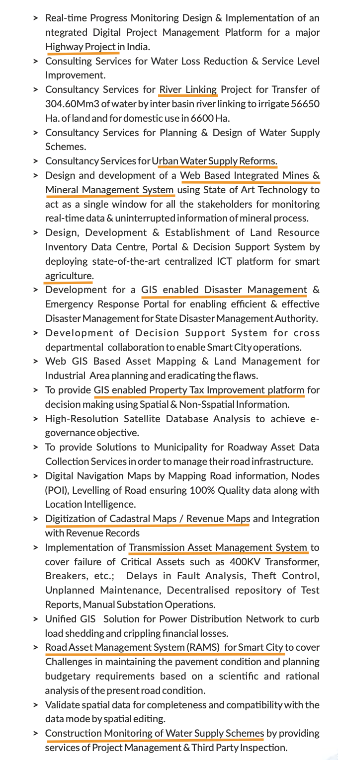
Here are some of the projects from Ceinsys AR which are across various sector from power, smart cities, water management, mines and minerals, agriculture, highways, property tax system, land records digitisation, digitisation of cadastral maps etc.
Ceinsys though attracted me from a value standpoint after their AllyGrow acquisition. I now realise that the opportunity size in geospatial business is rather large and shouldn’t be considered a legacy business by any means.
Sources
- Genesys - SoI partnership (Has demo their platform in the end) https://www.youtube.com/watch?v=LEXoJctkMd0&t=7s
- Sajid Malik interview - https://www.youtube.com/watch?v=-pJfJcD16eI&t=1206s
- Ceinsys Annual Report and AGM transcript
- Geospatial policy docs Feb ‘21 and Dec ‘22
Risks
- Business is dependent on govt’s whims and policy changes. Since this sector itself is rather new post policy shift of liberalisation, there is perhaps time to worry about this risk
- Govt. doesn’t have a history of paying on time - this may have changed in the recent couple of years but needs to be watched
- Both Genesys (Sajid Malik is BJP spokesperson Shazia Ilmi’s husband) and Ceinsys (part of Maharashtra MLA Sagar Meghe’s Meghe group) are politically connected to the ruling party. Political risks do exist in the long run though at present its fine
Disc: Invested in Ceinsys and Genesys