COMPANY NAME - GENESYS INTERNATIONAL
MARKET CAP - 1600 CRS. APPROX
CMP - 425
OVERVEVIEW OF THE COMPANY -
-
Company is a prominent player in the Indian geospatial industry and is renowned for creating engineering-grade high precision geospatial datasets.
-
Company creates cutting-edge 2D and 3D maps which are delivered to clients through a licensing model.
-
Genesys aligns its offerings to address critical needs like urban planning, disaster management, forestry, land management and utilities viz. telecommunications and power.
-
Through years of investments in 3D mapping the company has launched Genesys constellation - India’s largest collection of advanced ground sensors and aerial sensors. This is the only company in India which now has deployed every possible sensor configuration to map each and every inch of urban area.
-
The in-house software development team developed many 3D application use cases in various industry standard enterprise software platforms adhering to international geospatial standards.
HOW THE INDUSTRY IS LOOKING LIKE -
-
The geospatial industry is witnessing significant developments and innovations by leveraging real-time data, miniaturization of sensors, Geospatial Artificial Intelligence, 3D modelling, automation, LiDAR, Augmented Reality applications, Big data analytics and cloud computing.
-
One noteworthy trend in the indian geospatial market is the migration from 2D to 3D GIS. It is basically the visual representations of physical objects or systems in the real-world. This can help organizations to analyse and optimize complex systems such as urban infrastructure, factories and supply chains.
-
NGP 2022 seeks to strengthen the Geospatial sector to support national development, economic prosperity and a thriving information economy. This policy spells out the vision, goals for the Geospatial sector and outlines the strategies for achieving them.
-
Vision of the NGP are as follows - To make INDIA the world leader in Global Geospatial space, to move towards digital economy and improve services to citizens and easy availability of valuable geospatial data to private players
-
National Geospatial Policy (NGP) aims to achive high-resolution topographical survey and mapping with a Digital Elevation Model (DEM) of 5-10 cm for urban and rural areas and 50-100 cm for forests and wastelands by 2030.
-
Furthermore by 2035, GOI has plans to have high resolution/accuracy Bathymetric Geospatial Data of inland waters and sea surface topography to support the Blue economy.
THINGS THAT ARE LOOKING INTERESTING -
-
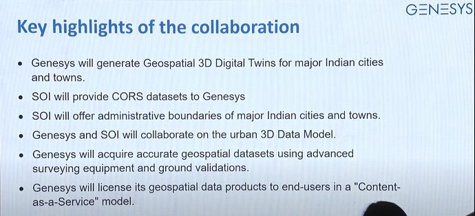
Company has tied up with survey of India to create a Digital Twin of major cities and towns of India. A digital twin is basically a replica of the real world.
-
This partnership aims to leverage Genesys’ all-India navigable maps, Genesys constellation of sensors and SOI’s recently launched CORS network, which allows real-time high precision positioning of data to create the Digital Twins.
-
Company secured an order recently to deploy Digital Twin mapping technology for the redevelopment of Dharavi, Asia’s most densely populated urban settlement.
-
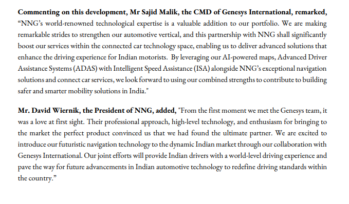
In the ADAS show 2023 at ICAT, Manesar the company showcased their high fidelity 2D Standard Definition (SD) map for India which covered 8.3 million km of roads and featured over 40 million points of interest setting a benchmark in accuracy and reliability.
-
Company recently setup an Executive Innovation Board(EIB) comprising industry luminaries with extensive expertise in mobility, e-commerce/logistics and automotive markets. EIB will be crucial in steering Genesys towards innovative solutions for India’s consumer and infrastructure needs.
-
Company has also received orders for the production and updating of national coverage maps of Saudi Arabia and 3D digital twin mapping for the City of Mecca, Saudi Arabia worth 67 crs. and 26 crs. respectively.
FINANCIALS -
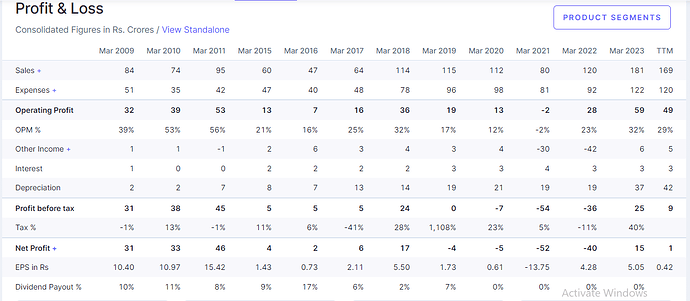
P&L
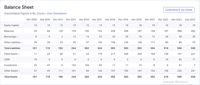
BALANCE SHEET
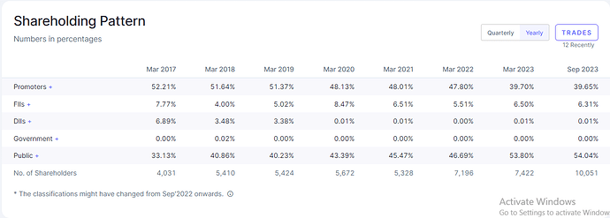
SHAREHOLDING
Financials of the company are not that encouraging as there has been almost no profitability. But it can be said that the company was in an investment phase all these years where they have invested money to develop the product.
Borrowings of the company have also not shot up very much as the company has raised some funds by way of preferential issue once in 2021, 750000 lakh shares @122 and then in 2022, around 12.76 lakh shares @470.
RISKS -
-
Cybersecurity is of a paramount concern as the geospatial industry relies heavily on digital data and cloud-based services.
-
Also the geospatial industry requires substantial investment in research, development and infrastructure. Marketing also takes away a huge chunk of the profits.
-
Valuations are not exactly cheap. Company has developed a good product that is fine but how much revenue and profitability will they be able to achieve is still not clear.
Disclosure - Invested 5% of my portfolio in it at various levels. Views can be biased.

